Ground Deformation Monitoring
Ground Deformation Monitoring
We deliver satellite-based ground deformation monitoring to mining operators, energy companies, and infrastructure owners worldwide. Our work supports critical decisions — from slope stability assessments to regulatory compliance — across some of the most demanding environments on the planet.
Who We Are
With over 20 years of experience, our team has monitored and interpreted ground movement for clients across six continents. We specialize in translating complex geospatial data into clear, decision-ready intelligence — when operational safety, infrastructure integrity, and regulatory compliance are at stake.
Our proprietary analytics platform integrates satellite InSAR, GNSS, and tiltmeter data into a unified, multi-sensor view of ground behaviour. This approach gives clients a complete picture of both vertical and horizontal movement, with the precision and reliability their operations demand.
What is InSAR?
InSAR (Interferometric Synthetic Aperture Radar) is a satellite-based remote sensing technique that detects ground surface movement with millimetre-level accuracy across areas spanning hundreds of square kilometres. By analyzing phase differences between radar images acquired at different times, it reveals subtle deformation patterns that no ground-based sensor could cover at equivalent scale or cost.
Unlike conventional monitoring methods, InSAR requires no on-site instrumentation, operates in all weather conditions, and provides continuous spatial coverage rather than isolated point measurements. For organizations managing large or remote assets — mines, oilfields, pipelines, dams — it represents a fundamental shift in how ground risk is assessed and managed.
Our Capabilities
We offer end-to-end ground deformation monitoring — from long-term regional surveillance programs to rapid-response assessments of emerging geohazards. Every engagement is supported by rigorous quality control and delivered through scalable, automated processing workflows.
- Subsidence monitoring: early detection of ground movement that could impact infrastructure, facilities, and operations.
- Mining & industrial monitoring: monitoring open-pit and underground mines, as well as tailings storage facilities, to ensure operational stability.
- Oil & gas operations: tracking enhanced recovery, underground gas storage, and wastewater injection to support safety, environmental protection, and regulatory compliance.
- Geohazard monitoring: detection of landslides, slope instability, and induced seismicity to safeguard people and assets.
- Custom geospatial analytics: tailored multi-sensor monitoring solutions for complex or specialized applications.
Deliverables include high-resolution deformation rate maps, displacement time-series, and interpretive reports — all produced through validated, automated workflows and calibrated against independent reference data.
Industries We Support
- Mining: open-pit slope stability, tailings dam integrity, underground subsidence monitoring
- Oil & Gas: reservoir operations, cavern monitoring, injection impact assessment
- Infrastructure & Transportation: urban subsidence, transportation corridors, dam safety
- Government & Environment: geohazard monitoring, regulatory compliance, environmental risk assessment
- Insurance: independent verification of ground risk and infrastructure stability
Across all sectors, our work is used to detect emerging risks before they become incidents — enabling timely intervention, reducing liability exposure, and supporting defensible, evidence-based reporting to regulators and stakeholders.
Trust & Confidentiality
Our clients include some of the world’s leading mining operators, energy companies, and government agencies. We understand that the data we handle is often commercially sensitive, operationally critical, or subject to regulatory scrutiny. Every project is conducted under strict confidentiality protocols, and our findings are shared exclusively with the client.
We do not publish client data, reference client names without explicit permission, or share findings across engagements. Our role is to support your operations — not to build our portfolio at your expense.
Project Highlights
The following examples illustrate the range and depth of our work — spanning urban subsidence, mining operations, energy infrastructure, landslide monitoring, and induced seismicity. Each project was processed using our multi-sensor InSAR platform, producing high-resolution deformation maps and displacement time-series for operational use.
 Large-Scale Subsidence
 Urban Subsidence
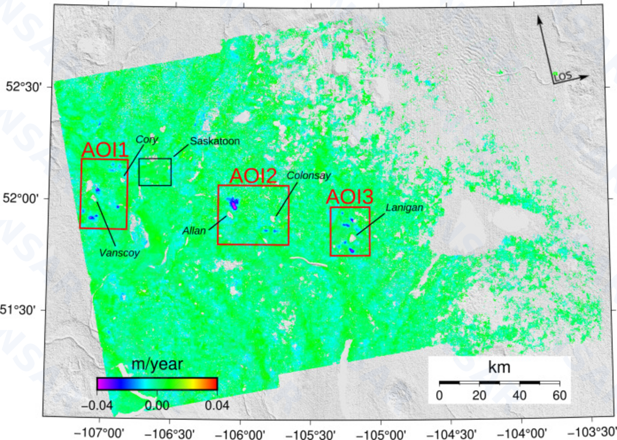
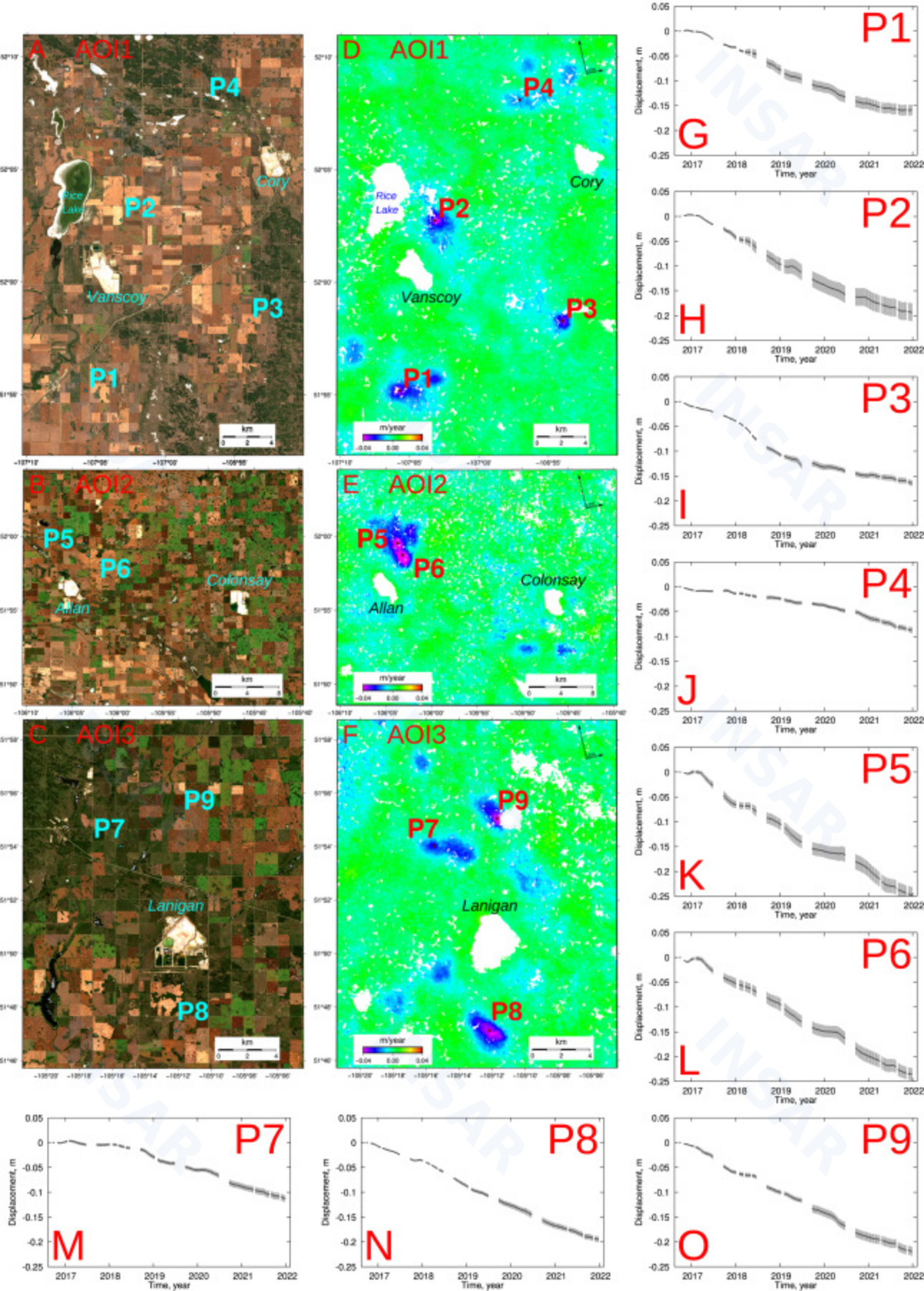
 Mining Deformation
 Oil & Gas Operations
 Wastewater Injection
 Induced Seismic Activity
 Landslides
 Other Monitoring
Large-Scale Subsidence


Urban Subsidence


Mining Deformation


Oil & Gas Operations


Wastewater Injection Impact
Induced Seismic Activity

Landslides


Other Monitoring Services


